
CustomWeather delivers real-time severe weather alerts for locations around the world. Developers, businesses, emergency managers, logistics providers, insurers, and travel applications use our API to receive official weather warnings, watches, advisories, and other hazardous weather notifications in JSON or XML.
Alerts are continuously monitored and updated as government meteorological agencies issue new information, allowing applications to notify users immediately when hazardous weather threatens a location.
Real-Time Weather Alerts:
Critical Data for Businesses
- Logistics & Fleet Management
- Aviation
- Insurance
- Utilities
- Agriculture
- Construction
- Smart Cities
- Outdoor Recreation
- Travel Apps
- Energy
- Public Safety
- Emergency Management
Alert Type
Description
Alert Type
Tornado Warning
Description
Immediate tornado threat
Alert Type
Severe Thunderstorm Warning
Description
Damaging winds, hail or lightning
Alert Type
Flash Flood Warning
Description
Risk of dangerous and rapidly developing flood conditions
Alert Type
Winter Storm Warning
Description
Snow, ice, blizzard conditions
Alert Type
Hurricane Warnings
Description
Tropical cyclone impacts
Alert Type
Heat Advisory
Description
Dangerous heat
Alert Type
Wind Advisory
Description
Strong or damaging winds
Alert Type
Coastal Flood Warning
Description
Risk of flooding in coastal or low-lying areas
Alert Type
Fire Danger Warning
Description
Elevated wildfire conditions
Alert Type
Dense Fog Advisory
Description
Reduced visibility
Weather Alert Response Includes
- Alert ID
- Event type
- Severity
- Urgency
- Certainty
- Effective time
- Expiration time
- Issuing authority
- Geographic polygon
- Description
- Recommended actions
Sample XML response
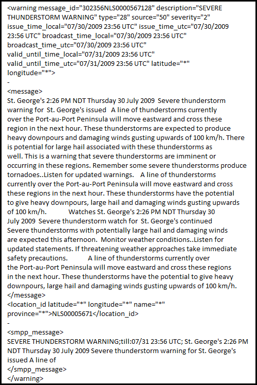
<warning message_id="011412KYC1777" description="Flood Warning" type="7" nws_office="NWS Paducah KY" source="9" severity="4" severity_level="Severe" issue_time_local="07/01/2026 09:12 CDT" issue_time_utc="07/01/2026 14:12 UTC" broadcast_time_local="07/01/2026 09:12 CDT" broadcast_time_utc="07/01/2026 14:12 UTC" valid_until_time_local="07/03/2026 13:00 CDT" valid_until_time_utc="07/03/2026 18:00 UTC" effective_time_local="07/01/2026 09:12 CDT" effective_time_utc="07/01/2026 14:12 UTC" parent_id="" name="Powderly" state_name="Kentucky" country_name="United States" latitude="37.22" longitude="-87.14">
<message>
The National Weather Service in Paducah KY has issued a Flood Warning for the following rivers in Kentucky. Green River at Paradise. .Recent heavy rainfall will result in minor river flooding at Paradise. For the Green River. including Paradise. Minor flooding is forecast. * WHAT. Minor flooding is forecast. * WHERE. Green River at Paradise. * WHEN. From late tonight to early Friday afternoon. * IMPACTS. At 380.0 feet, Water rises over the skimmer wall at the TVA fossil plant. * ADDITIONAL DETAILS. - The river was at 379.7 FT this July 1st morning at 8:15 AM CDT. - Forecast. The river is expected to rise above flood stage after midnight tonight to a crest of 380.2 feet early tomorrow afternoon. It will then fall below flood stage Friday morning. - Flood stage is 380.0 feet.
</message>
<polygon>
37.46,-87.16 37.42,-87.03 37.26,-86.89 37.20,-86.97 37.29,-87.07 37.31,-87.19 37.46,-87.16
</polygon>
<county_id latitude="37.2157" longitude="-87.1421" name="Muhlenberg" country="US" country_name="United States" state="KY" state_name="Kentucky">KYC177</county_id>
<smpp_message>
Flood Warning;till:07/03 13:00 CDT; The National Weather Service in Paducah KY has issued a Flood Warning for the following rivers in Kentucky. Green River at
</smpp_message>
</warning>
Government-Issued Alerts (US and Canada)
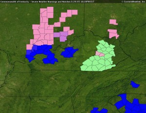
County-Specific Severe Weather Watches & Warnings
Severe Weather Alerts (United States)
- Real-time severe weather alerts for the entire US
- Alerts are provided as soon as they are issued by the National Weather Service
- No other weather provider offers real-time access to this information in so many unique technical formats.
Environment Canada Severe Weather Alerts (Canada)
Sample Environment Canada Alert
Real-Time location-specific warnings, watches, and advisories issued by Environment Canada.
- Alerts are categorized according to 38 alert types including thunderstorm warnings, winter storm warnings, marine warnings, and wind advisories.
- Alerts are limited to within Canada.
- Canadian alerts are also offered as part of a U.S.-Canada combined alert product.
Custom Alerts and Advisories (available worldwide)
Custom Alerts
Custom Alert Email
- Custom alerts can be generated for any specific weather criteria
- Alert criteria can be in the past based on climate data or in the future based on weather forecasts
- Weather alerts can be generated that incorporate both past and future weather data
- Custom alerts can be sent out via email to specific user groups, via FTP, or via SMS using carrier email-to-SMS transmission

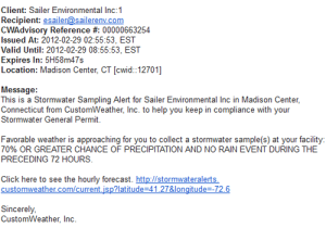
Sample Observation Alert
Current Condition Observation Alerts
- Alert notifications of severe weather events based on thousands of global, real-time current condition reports.
- Alerts are issued against standard criteria or customized for client requirements.
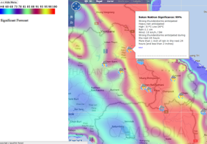
Sample Forecasted Significant Weather Alert
Forecasted Significant Weather
- Forecasted Significant Weather highlights areas with the most significant weather as compared to climatology.
- Created to be used in conjunction with Severe Weather Advisories.
- Forecasted Significant Weather uses a ranking of 0-100 to indicate the significance of weather in a particular location with a focus on precipitation, winds, and temperature.

Severe Weather Advisories
Global Severe Weather Advisory System
- First and only worldwide severe weather advisory system.
- Our advisories inform people around the globe of potentially dangerous or severe weather conditions in their local area BEFORE they happen.
- Advisories are updated four times daily and are available for 80,000+ worldwide locations.
- Advisories cover the next 24 hours.
- Options for upcoming 6 hours, 48 hours, and upcoming 5 days are also available.
Examples include:
- Precipitation
- Lightning Strider Alerts (US only)
- High winds
- Freeze alerts
- Ice accretion
- Extreme heat alerts
- Hail potential
- Tornado potential
- Surf alerts
- Tropical storm updates

Hail
Real Time Hail Tracking (USA)
- Track the size and movement of storm cells containing hail based on Doppler Radar signature
- Provides the probability of hail associated with a storm cell
- Indicates the maximum hail diameter reported
- Available through our API in XML format
- Data also available in a map tile interface with scroll-overs for additional detail
Also included:
- Presence of any tornado vortex signatures
- Vertically integrated liquid
- Maximum Doppler Radar response
- Storm cell top height
- Storm cell movement
Hail Forecast (Global)
- Hail forecast is available as a Cloud Weather Service (CWS) plug-in.
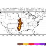
Sample Hail Forecast
- Forecast for a probability of significant hail is available out to 7 days.
- The criteria for significant hail has been defined by the Storm Prediction Center

Flood
Globally available flood risk is based on past, current, and future precipitation compared to typical during a given period.
Flood Risk
- Precipitation observations and forecasts are dynamically integrated over time to capture flood potential as it relates to given conditions across the landscape.
- Flood forecasts are available day-by-day at 10km with regional scales to 1km.
- Flood risk is broken into 5 categories – Low, Moderate, High, Very High, and Severe.
- Data can be delivered as kmz/kml, map tile, geojson, or geotiff/shapefile/geopackage

Icing Index
Icing index for any global location is available via CustomWeather’s Cloud Weather Service.
Icing Forecasts
- Surface forecasts for categorical freezing rain
- Categorical ice pellets
- Percentage frozen precipitation
- Frozen rain
- freezing rain
- highest tropospheric freezing level geopotential height
- 0°C isotherm geopotential height
Lightning (North America)
Accuracy within 150 meters | Near 100% efficiency rating | Timing to the microsecond | Reporting within 12 seconds.
Flexible Data Access
All lightning datasets are available through our APIs for seamless integration into your systems:
Weather Essentials API
Cloud Weather Services API
Weather Essentials API
Formats: JSON, XML
Cloud Weather Services API
Formats: netCDF (gridded datasets)
Weather Essentials API
Real-time lightning densityLightning probability forecasts
Cloud Weather Services API
Ideal for modeling, GIS, and advanced analytics workflows
Built for High-Stakes Applications
- Aviation & Airports
- Energy & Utilities
- Outdoor Events & Recreation
- Construction & Infrastructure
- Insurance & Risk Management
- Government & Emergency Services
Lightning Alerts via Email
- Real-time lightning alerts via email can be delivered for specific locations across North America
- Alerts are sent according to user-defined distance thresholds (typically 5 or 10 miles)
Example alert via email:
Notification Rule: Lightning - 10 mi

Lightning alert within 10mi 30min

Lightning Distance: 7.31 miles
Stroke Location: Lat: 29.6919 Lon: -95.1554
Type: IC
Peak Current: +11.658 kA

Activated Time: 08/18/2021 02:41:41 PM CDT
Real Time Lightning Intelligence at 1 km Resolution
- CustomWeather delivers high-resolution lightning intelligence across the Continental United States, combining real-time observations with short-term predictive insight. Built for precision and speed, this dataset helps organizations detect, monitor, and respond to lightning risk as it evolves.
Lightning Probability Forecasts (0–60 Minutes)
In addition to real-time observations, CustomWeather now provides short-term lightning probability forecasts across the Continental U.S.
Forecast horizons:
- Next 30 minutes
- Next 60 minutes
Key benefits:
- Anticipate lightning risk before it occurs
- Improve decision-making lead time
- Reduce exposure for personnel, assets, and operations
- Continuously updated for evolving storm conditions
Lightning Density Data (Real-Time)
Our lightning density dataset provides cloud-to-ground lightning activity at 1 km spatial resolution, measured as:
Flashes per square kilometer per minute
Available time aggregations:
- 1-minute (near real-time precision)
- 5-minute
- 15-minute
- 30-minute
This data enables you to:
- Trigger instant lightning alerts
- Monitor strike intensity trends
- Identify rapidly developing storm hazards
- Enhance safety protocols for outdoor operations
Why CustomWeather?
- High-resolution (1 km) nationwide coverage
- Minute-level updates for real-time awareness
- Integrated observations + forecasts
- Developer-friendly APIs
- Proven reliability for mission-critical operations
Need a Custom Solution?